


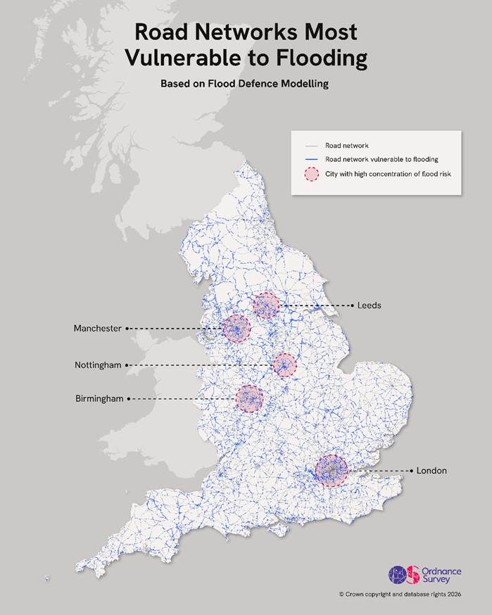
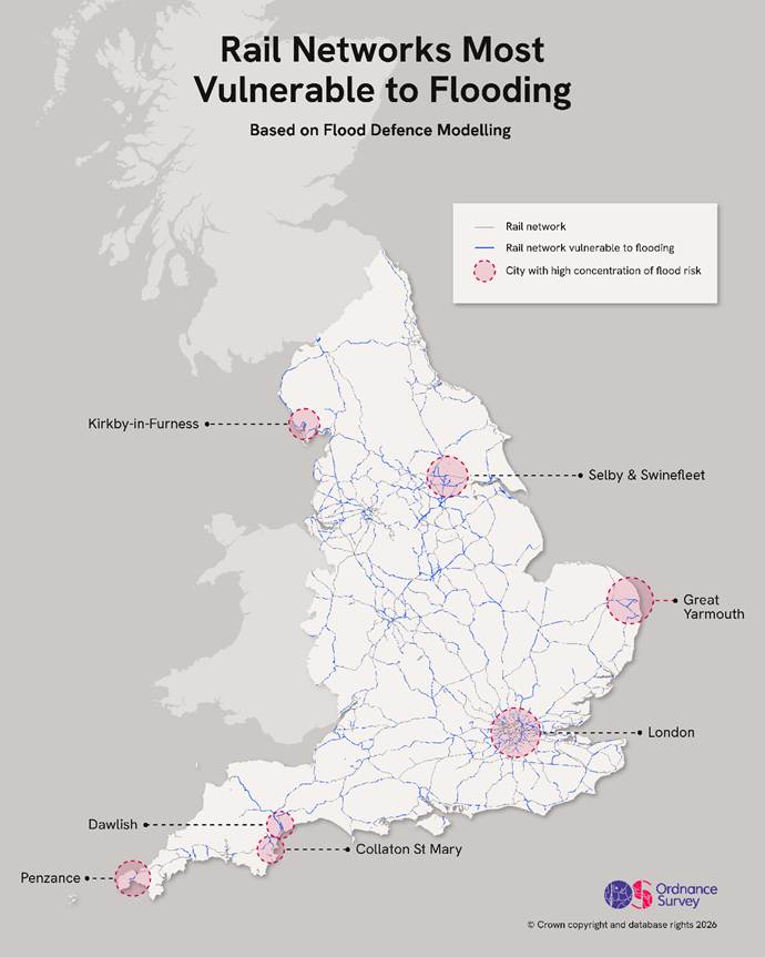
20% of England’s rail network and 12% of roads are at risk of rising sea and river levels brought about by more extreme weather.
An analysis of land use and the likelihood of climate change-driven flooding, conducting by Ordnance Survey, has identified so-called ‘road and rail pinch points’ across England. These are locations where transport corridors are most susceptible to river or coastal flooding.
Using the OS National Geographic Database and Environment Agency flood data, it found 12% of roads (7,500km) and 20% of the rail network (3,003km) was exposed to potential risk. 587km of motorway fell within the highest risk category, with the A38 most vulnerable, followed by the M45, M32 and A58.
North Yorkshire was found to be the most vulnerable authority, with 102km of road susceptible to river flooding and 49km threatened by sea flooding. Kirkby-in-Furness, Collaton St Mary, Swinefleet, Belton, Bradwell and Burgh Castle were all found to have a reasonable chance of being cut off and isolated from the national rail network by coastal waters.
Meanwhile, commuter lines in Marlow and Henley-on-Thames could become inaccessible due to river flooding. Other areas which could see rail services flooded out include Penzance, King’s Lynn, Walsall, Stamford, Exeter, and York.
In major urban region, Greater Manchester’s ‘second city’, Salford, has 43 at-risk access roads — 66% of the total number in the borough. Nearby, 47% of roads in Old Trafford are exposed, with 45% of those in Central Manchester itself also under threat.
In comparison, Greater London is home to four areas which are exposed, with Kingston-upon-Thames ranking highest, followed by Sutton, Waltham Forest, and Hounslow. Newham was found to be most at risk of isolation from flooding. Leeds, Nottingham and Birmingham also had significant concentrations of roads and rail lines threatened by flooding.
‘Disruption from flooding on rail and road networks is increasing as climate change continues, turning what was once an occasional challenge into a persistent planning reality,’ said Tom Gray, Transport Market Development Lead at Ordnance Survey. ‘In this context, the ability of central government, local authorities and planners to rely on comprehensive, accurate geospatial insights is essential to reduce risk, protect communities and strengthen long-term resilience.’
‘With economic growth increasingly driven by new housing, infrastructure and major construction projects, investment is flowing into assets that must be resilient from day one,’ he continued. ‘These projects depend on secure funding, compliance with climate resilience regulations, ESG reporting metrics, appropriate insurance and effective mitigation measures – all of which require a clear, forward-looking understanding of environmental risk.’
Images: Tolu Akinyemi 🇳🇬 / Unsplash (Top), Ordnance Survey (Maps)
More on Transport:
Bradford Council launches Beryl e-bike share scheme with LNER
WATCH: Stockholm’s ‘flying ferry’ slashes emissions by 94%, halves journey times