


Improving flood resilience in towns and cities
A new tool that assesses how resilient an urban area is to flooding has been put to the test in Hamburg. It could help planners to design towns and cities with floods in mind
Not all floods can be prevented but their impacts can be reduced; this is the current thinking in flood risk management, endorsed by the EU’s floods directive.
It represents a shift from conventional forms of flood management which attempt to avoid flooding using physical infrastructure, such as barriers. Cities must become more prepared for floods, because climate change, population growth and urbanisation are changing the causes of flooding and increasing its impacts.
‘Resilience’ – the ability to cope with disturbance and ultimately to recover – is an idea that proposes cities can cope with unexpected shocks, such as flooding, but this concept can be difficult to apply pre-emptively, in reality.
Researchers from universities in France and Belgium used their existing tool for assessing resilience — called the DS3 model — and adapted it to study a particular neighbourhood in Hamburg. They believe that the tool could help planners to design towns and cities that are more resilient to floods by identifying the features that increase flood resilience.
The neighbourhood scale provides a good focus for experimenting and testing new strategies or measures, because the effects are more immediate than for larger scales, the researchers explain. The tool provides a method for analysing operational relationships between a neighbourhood’s functional components (e.g. buildings, roads, green spaces) and external environmental factors under normal and flooding conditions, to identify dependencies and criticality.
It allows planners to consider how urban design features contribute to three capacities of resilience at the neighbourhood scale:
- Resistance — the ability of a neighbourhood to reduce damage to its major infrastructure (neighbourhood components that are essential to operation).
- Absorption — the ability of a neighbourhood to operate despite damage to major infrastructure. This usually involves the provision of alternative systems, if one system stops working.
- Recovery — the ability of a neighbourhood to bring major infrastructure back into operation.
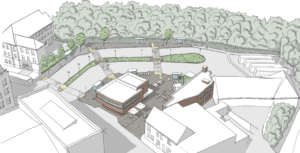
To demonstrate the method, the researchers applied it to a neighbourhood in Hamburg called , which is in the redeveloped waterfront district of HafenCity. Finished in spring 2009, following six years of construction, the neighbourhood is occasionally exposed to storm surges, when high tides increase the water level by up to six metres above average sea level. It has a dense mix of different uses — housing, work and leisure — with approximately 137 inhabitants per hectare. A number of urban features increase Am Sandtorkai/Dalmannkai’s flood resilience, the tool shows.
It classifies these features into three categories:
- Connections
- Design measures
- Specific neighbourhood components
An example of connections which improve resilience is transport connections, which are shown to be particularly important for this neighbourhood. For example, a bridge which connects the neighbourhood with the rest of the city is resistant to damage because it has been constructed eight metres above sea level. It is normally only for pedestrians and cyclists, but during a storm surge would also be open to rescue vehicles, which boosts the neighbourhood’s absorption capacity and could allow the area to recover more quickly.
Design measures which enhance resilience include open public spaces, such as green areas and promenades along the waterside, the tool indicates. These are built at a lower level than buildings and can take occasional flooding without disrupting or damaging the rest of the neighbourhood.
Flood-proof basements provide an example of a specific neighbourhood component that boosts resistance and recovery capacities by reducing damage to buildings and allowing them to continue operating during floods.
Each neighbourhood has its own unique circumstances and the features that work for one neighbourhood cannot necessarily be transferred directly to another neighbourhood. However, the tool can increase urban designers’ awareness of how flood resilience can be put into practice.
- Source: Science for Environment Policy, November 18, 2016, What makes an urban neighbourhood more resilient to flood? European Commission DG Environment News Alert Service, edited by SCU, The University of the West of England, Bristol. To access articles and to subscribe, please go to http://ec.europa.eu/science-environment-policy
Photo by Tony Webster 