

May 2nd 2023
River Thames Scheme: Sustainable land use, nature recovery, flood protection
The River Thames Scheme is taking an integrated, landscape-based approach to flood protection, sustainable land use, nature recovery and local wellbeing. Project Environment Manager Richard Woodward explains the details.

The Government’s Environmental Improvement Plan (EIP), published in January, refreshed the commitments and priorities for environmental protection first set out in the 25 Year Environment Plan. In the very same week, Natural England published its Green Infrastructure Framework (NEGIF) setting out principles for greening towns and cities and connecting people with nature.
These are the latest additions to a body of policy and plans that collectively present a vision for new infrastructure to deliver an integrated approach to climate-resilient and sustainable land use, nature recovery and improvements to health and wellbeing. The River Thames Scheme (RTS) is putting this vision into action.
A unique approach to a complex challenge
The RTS is a unique project. It is the first of its kind to be designated an infrastructure project of national significance. As a co-delivery project between the Environment Agency and Surrey County Council, it also benefits from a unique collaboration agreement that is at the forefront of partnership working. And importantly, as a landscape-based solution to delivering green and blue infrastructure with multiple benefits, it is forging a new approach to climate adaptation, to place-making and a more sustainable future.
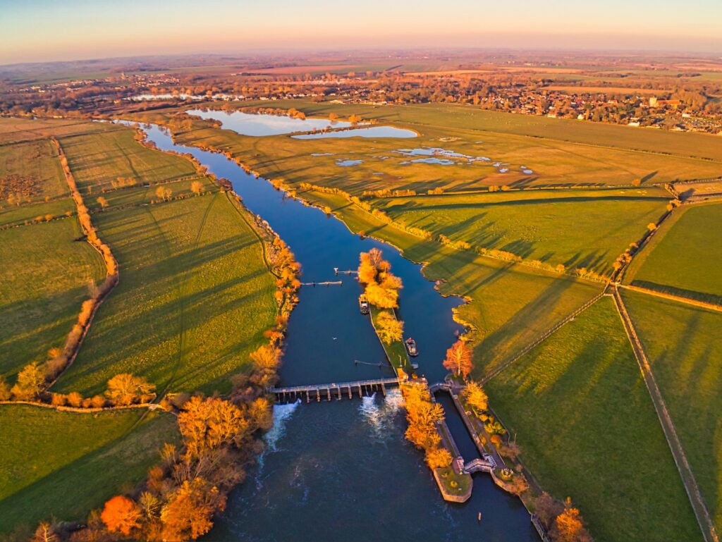
Between Egham in Surrey and Teddington in South-west London, the River Thames runs through the largest area of populated but undefended flood plain in England. The landscape has been shaped by urban development, industrial activity, minerals workings and major infrastructure. Many of the region’s built-up areas are vulnerable to flooding and much of its open space is inaccessible. There are important areas of wildlife such as the River Thames, Thorpe Hay Meadow SSSI and the South West London Waterbodies Special Protection Area, but outside of these areas the biodiversity is degraded and fragmented.
Drawing on the principles set out in the EIP and NEGIF, the RTS has been developed to respond to these multiple challenges by delivering an integrated blue and green infrastructure project which provides a combination of flood risk benefits, habitat for wildlife, new green and blue spaces and active travel enhancements.
How it works
Currently still in the design stage, the project will include a five-mile (8km) river channel built in two sections through the boroughs of Runnymede and Spelthorne in Surrey, flanked by new areas of green open space for recreation and wildlife and new footpaths and cycleways to increase connectivity and sustainable travel.
There will also be works to the river near Desborough Cut (an excavated channel created in the River Thames near Shepperton in the 1930s) and the weirs at Sunbury, Molesey and Teddington to increase flow capacity.
The benefits to the local community will be substantial and multi-faceted. By carrying additional flow from the River Thames during flood conditions, the channel and the additional weir gates will greatly reduce the risk of flooding, benefiting more than 11,000 homes and 1,600 businesses as well as key elements of infrastructure. This will help these communities to thrive and develop without the fear and uncertainty that comes from being at a high flood risk.
Yet even when not protecting against flooding, the channel will provide a new landscape feature for people and wildlife. Blue and Green Infrastructure is designed to be multi-functional, supporting nature recovery, helping create active and healthy places and thriving communities, enabling water management and providing climate resilience. The RTS will deliver across all these fronts. 
A new resource for nature
Nature recovery is a national priority, and the RTS will build on the wildlife networks that already exist in this area and support local nature restoration.
In normal circumstances, when there is no flooding, the new river channel will still contain water and in many sections will look like an established river. The gently flowing water and shallow planted banks will create habitat and link into new areas for nature, creating more wildlife corridors, supporting existing wildlife sites and benefitting local species.
One highlight from our recent data gathering was the discovery of a nationally rare mayfly (Caenis beskidensis), that was last spotted in Herefordshire in 1973. The find indicates an expansion in the distribution and habitat type associated with the mayfly, and the project will create more habitat to support this rare species.
Alongside the channel, the project will be looking to integrate high quality habitat and biodiversity improvements throughout. Floodplain wetlands are quite rare in Surrey, especially along the larger river systems such as the Thames, and this is another area where the RTS is hoping to make a real difference by creating low-lying areas of seasonally inundated or permanently wet habitats along the Thames corridor.
Green spaces for healthier communities
The EIP and NEGIF recognise the importance of providing access to areas of nature and public open green space for communities. The RTS will create several new areas for people to visit and spend time outdoors, connecting with nature to support physical and mental health and well-being. To further support active lifestyles and sustainable travel, the project will integrate and enhance the existing network of footpaths and cycleways throughout the area.
In addition to responding to policy priorities, it is vital that these areas also meet the needs and aspirations of the local communities, which is why stakeholder engagement is such an important part of the design process. The RTS recently ran a successful consultation with communities and stakeholders, speaking to more than 1,200 people via 10 face-to-face exhibition events and seven virtual events. This engagement is continuing through this year and a further consultation is scheduled for the winter.
The challenges of developing such a large and multi-faceted infrastructure project in this part of Surrey are substantial, but so too are the opportunities for positive change. The RTS is a unique example of an integrated green and blue infrastructure project which responds to current environmental policies and initiatives, but crucially, also seeks to translate those ambitions into the very specific needs and aspirations of the local community.
Images: Nick Fewings (Top) / Lawrence Hookham (Middle) / Richard Woodward (Bottom)